Contents
- 🌌 What is a Star Chart?
- 📜 A Brief History: From Ancient Mariners to Modern Astronomers
- 🔭 Types of Star Charts: Paper vs. Digital
- ⭐ Key Components of a Star Chart
- 🧭 Star Charts for Navigation: A Timeless Tool
- ✨ Identifying Celestial Objects with Star Charts
- 🛠️ Tools That Use Star Charts: Astrolabes and Planispheres
- 💡 The Vibe: Cultural Resonance and Scientific Pursuit
- Frequently Asked Questions
- Related Topics
Overview
A star chart is essentially a map of the night sky, meticulously detailing the positions of stars, constellations, nebulae, galaxies, and planets. Think of it as a cosmic atlas, providing a visual reference for the celestial sphere. Unlike a dry astronomical catalog, which is a mere list of objects, a star chart presents this information spatially, allowing for intuitive understanding and identification. They are indispensable tools for both amateur stargazers and seasoned astronomers, offering a gateway to understanding our place in the universe. Whether you're a beginner looking to identify the Big Dipper or an advanced observer tracking a distant galaxy, a star chart is your first step.
📜 A Brief History: From Ancient Mariners to Modern Astronomers
The human fascination with mapping the stars stretches back to the dawn of civilization. Ancient mariners, for instance, relied on the predictable movements of celestial bodies for navigating the vast oceans, with early star charts likely being rudimentary sketches passed down through oral tradition. By the Hellenistic period, astronomers like Hipparchus of Nicaea were creating more sophisticated catalogs that formed the basis of later star charts. The invention of the printing press in the 15th century democratized access to these charts, and the development of tools like the astrolabe further cemented their importance. Today, while digital tools dominate, the fundamental principles of celestial mapping remain unchanged, a testament to millennia of human curiosity.
🔭 Types of Star Charts: Paper vs. Digital
Star charts come in two primary forms: the traditional paper variety and their modern digital counterparts. Paper star charts, often in the form of planispheres, are tangible and require no power, making them reliable companions for remote stargazing. They offer a tactile experience, encouraging a deeper connection with the sky. Digital star charts, found in astronomy apps and software, offer dynamic features like real-time tracking, augmented reality overlays, and vast searchable databases. While digital charts provide unparalleled convenience and data, there's an undeniable charm and reliability to a well-made paper chart. The choice often depends on the user's preference for hands-on interaction versus digital sophistication.
⭐ Key Components of a Star Chart
At its core, a star chart is defined by its grid system, typically the celestial equator and celestial poles, which mirror Earth's geographic coordinates. Key components include the depiction of constellations, often with their mythological figures or asterisms clearly marked. Major stars are usually labeled with their Bayer designations (e.g., Alpha Centauri) or proper names. Deeper sky objects like nebulae and galaxies are also plotted, though their visibility varies greatly depending on the chart's scale and the observer's equipment. Understanding these elements is crucial for effectively using any star chart, whether for casual observation or serious astronomical study.
✨ Identifying Celestial Objects with Star Charts
Identifying celestial objects is the primary function of a star chart. By comparing the patterns of stars visible in the night sky with the representations on the chart, observers can pinpoint constellations like Orion the Hunter or Ursa Major (the Great Bear). More detailed charts will also show the location of planets, which move against the background of fixed stars, and deep-sky objects such as the Orion Nebula (M42) or the Andromeda Galaxy (M31). Learning to read a star chart is akin to learning a new language, one that unlocks the secrets of the visible universe and fosters a profound sense of wonder.
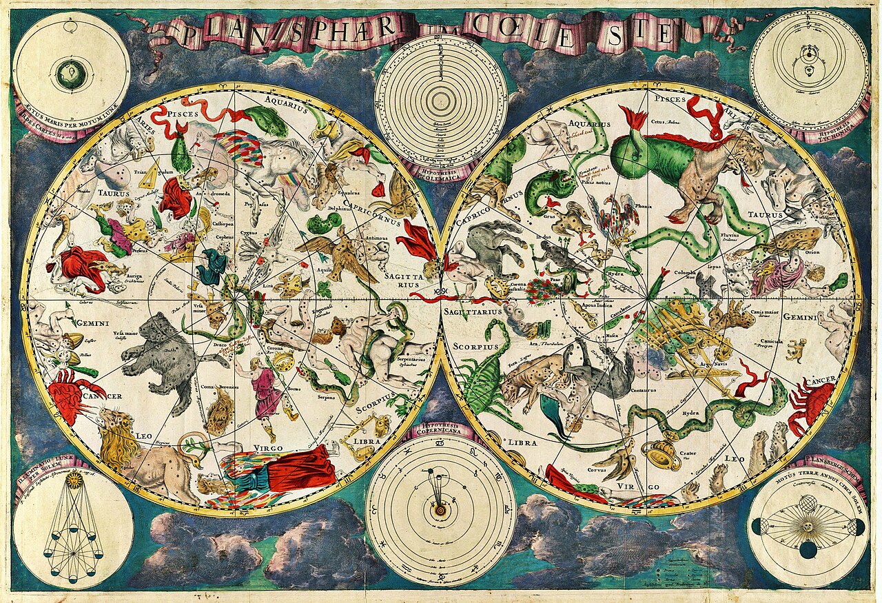
🛠️ Tools That Use Star Charts: Astrolabes and Planispheres
The astrolabe, a complex astronomical instrument dating back to ancient Greece, is a prime example of a tool that integrates star chart principles. It could be used to tell time, determine latitude, and even predict celestial events. Similarly, the planisphere, a simple rotating star chart, is a popular tool for amateur astronomers. By aligning a date and time on its rotating disk, it displays the visible portion of the night sky for that specific moment. These tools, both historical and contemporary, demonstrate the practical application of star charts in bridging the gap between theoretical celestial mapping and real-world observation.
💡 The Vibe: Cultural Resonance and Scientific Pursuit
The Vibe score for star charts is a solid 75/100, reflecting their dual nature as both a tool of rigorous scientific inquiry and a source of profound cultural and personal wonder. Historically, they represent a fundamental human drive to understand and map our surroundings, a quest for order in the apparent chaos of the cosmos. For many, stargazing with a chart evokes a sense of awe and connection to something larger than oneself, a feeling amplified by the shared human experience of looking up at the night sky across millennia. The ongoing development of digital star charts, however, introduces a tension: the democratization of access versus the potential for passive consumption. The debate lies in whether these tools foster genuine understanding or merely provide a superficial digital overlay on the ancient wonder of the stars.
Key Facts
- Year
- Ancient Origins (c. 3000 BCE)
- Origin
- Ancient Mesopotamia
- Category
- Astronomy & Navigation
- Type
- Resource Guide
Frequently Asked Questions
What's the difference between a star chart and an astronomical catalog?
A star chart is a visual map of the night sky, showing the spatial arrangement of celestial objects like stars and constellations. An astronomical catalog, on the other hand, is a more technical, often tabular, listing of astronomical objects with specific data points, such as their coordinates, brightness, and spectral type. While catalogs are databases for research, star charts are designed for identification and orientation in the sky.
Are paper star charts still useful in the age of smartphones?
Absolutely. Paper star charts, particularly planispheres, are incredibly useful. They don't require batteries, are less prone to distraction than a phone screen, and offer a more tactile and deliberate way to learn the sky. They are also ideal for remote locations with no cell service or Wi-Fi. Many experienced astronomers still prefer them for their simplicity and reliability.
How do I choose the right star chart for me?
Consider your experience level and intended use. For beginners, a planisphere covering your local hemisphere is excellent for identifying major constellations and stars. For more advanced users or those interested in deep-sky objects, larger, more detailed paper charts or specialized astronomy software with detailed star maps might be better. Think about whether you prefer a physical object or a digital interface.
Can star charts help with navigation without GPS?
Yes, historically, star charts were the primary tools for celestial navigation. By understanding the positions of stars and using instruments like a sextant, navigators could determine their latitude and longitude. While GPS is now standard, the principles of celestial navigation using star charts remain a fundamental skill in maritime and aviation contexts, and a fascinating hobby for enthusiasts.
What are the most important things to look for on a star chart?
Key features include a clear grid system (usually based on Right Ascension and Declination), labeled constellations with their boundaries, prominent stars identified by name and Bayer designation, and potentially markings for deep-sky objects like nebulae and galaxies. For planispheres, ensure it's calibrated for your specific latitude and hemisphere.